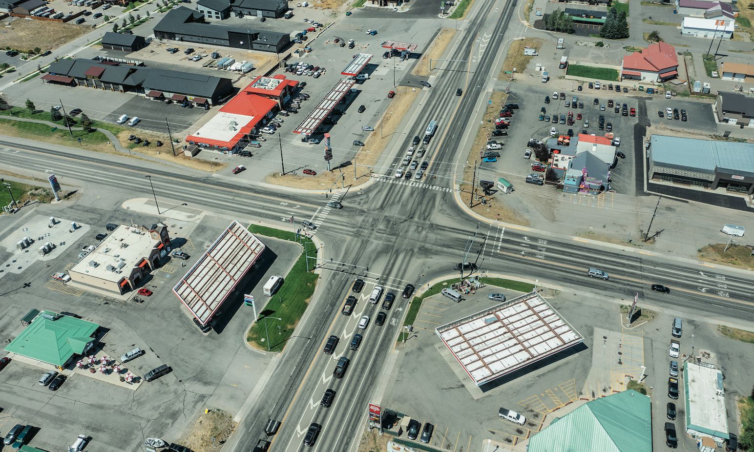
In 45°40.185653N, 111°11.104876W (2023, Stephen Shore used drone technology to present unique views of rural Montana
Courtesy of the artist and MACK
“Over the years, I’ve been interested in seeing how different cameras open different possibilities,” writes the American photographer Stephen Shore (born 1947) in his recent memoir, Modern Instances. “Sometimes picking up a new camera was like seeing the world with fresh eyes.” Shore made one such transition in the late 1970s, swapping his 35mm Leica—the lightweight camera (loaded with colour film) with which he shot his groundbreaking series, American Surfaces (1972-73)—for an 8” by 10” large-format device mounted on a tripod, responsible for the patient, structured photographs of Uncommon Places (1982).
Now, Shore returns with a series of works made during the Covid-19 pandemic: a suite of aerial photographs taken with a hi-tech drone, a new way to see the American surface. The pictures in Topographies: Aerial Surveys of the American Landscape are landscapes, a drone’s-eye view of rural Montana (where Shore was living during lockdown) alongside shots made in Wyoming, Nebraska, New York and Virginia. There is a stillness to the images, an uncanny quiet that reflects the world brought to a sudden halt. At the same time, it is hard to avoid the drone’s inherent voyeurism, a point of view at once invasive and enquiring; certain pictures carry a sense of discovery, of finding out the previously hidden or inaccessible.
The photographs are connected through their shared language of boundaries, the infinite edges and borders that stitch America together: fences, rivers, pipelines, railroads and—of course—the endless highways, roads and dirt tracks linking one place to another. They also explore the interconnectedness—what the critic Richard B. Woodward refers to in an introductory essay as “American interdependence”—of the human and the natural worlds. Taken together, they offer not so much a map as a quilted environment, a patchwork of fields, farmlands and mountain ranges, small towns and parking lots, forests and lakes; backyards and baseball diamonds; scrublands and cemeteries.
One picture shows a deep, black reservoir with steep, quarried sides. Beyond that, trees (just now turning orange), a slice of blue river, a town with a suspension bridge. Further out, another river, sprawling forests, distant hills; the rest of America, wide-angled skies. “At a certain height, one can begin to comprehend adjacencies within the landscape,” writes the academic and urban historian Noah Chasin in his prefatory essay, “The manifestation of borders between one thing and another”.
46°11.409946N, 110°44.018901W (2023) offers another Stephen Shore view of rural Montana
Courtesy of Stephen Shore and MACK
As its title suggests, Shore’s recent work is building on the impact of 1975’s New Topographics: Photographs of a Man-Altered Landscape, a landmark exhibition where he featured alongside Robert Adams, Frank Gohlke and others. Curated by William Jenkins, the show championed a shift away from the Romantic landscapes of the American West, turning instead to work aimed at the built and human-shaped environment.
While chiming with Edward Burtynsky’s abstract aerial images in The Anthropocene Project (2018) and the elevated vantage points of Andreas Gursky, Shore’s drone pictures also connect him to an earlier generation of American photographers engaged in capturing the changing landscapes of the US, particularly his favoured Walker Evans. They even echo paintings by the 19th-century English-American landscape painter Thomas Cole, showing the early signs of settlement encroaching on the wilderness.
Shore’s pictures in Topographies are paired with their co-ordinates; look to the index and you’ll find not only the location but the date, the height and to-the-second timestamps. These details provide a strange geo-temporal exactness, but also emphasise a kind of anonymity. Flipping through the photographs, one has the double sense that they could be of almost anywhere: unique and nowhere in particular. This feeling is prompted, perhaps, by the drone’s unavoidable transformation of the world into a model of itself, a simulation exposing the inherent sameness and repetition of the American surface. “America is a giant hologram of itself, in the sense that information concerning the whole is contained within each of its elements,” suggests the sociologist Jean Baudrillard in his influential cultural survey, America (1988). “Take the tiniest little place in the desert, any old street in a Midwestern town, a parking lot, a Californian house, a Burger King or a Studebaker, and you have the whole of the US.”
Nevertheless, Shore’s photographs are grounded in specifics and discoveries: a white horse, a junkyard, a road sliced through a rockslide; specks of cattle, derelict factories, scorched patches of earth and ash left over after forest fires. These are “the details of a lived reality”, writes Woodward, continued evidence of Shore’s ability to shine a light on what is already there.
• Topographies: Aerial Surveys of the American Landscape. By Stephen Shore with essays by Noah Chasin and Richard B. Woodward
MACK, 208pp, 97 colour illustrations, £65 (hb), published 9 January

