[ad_1]
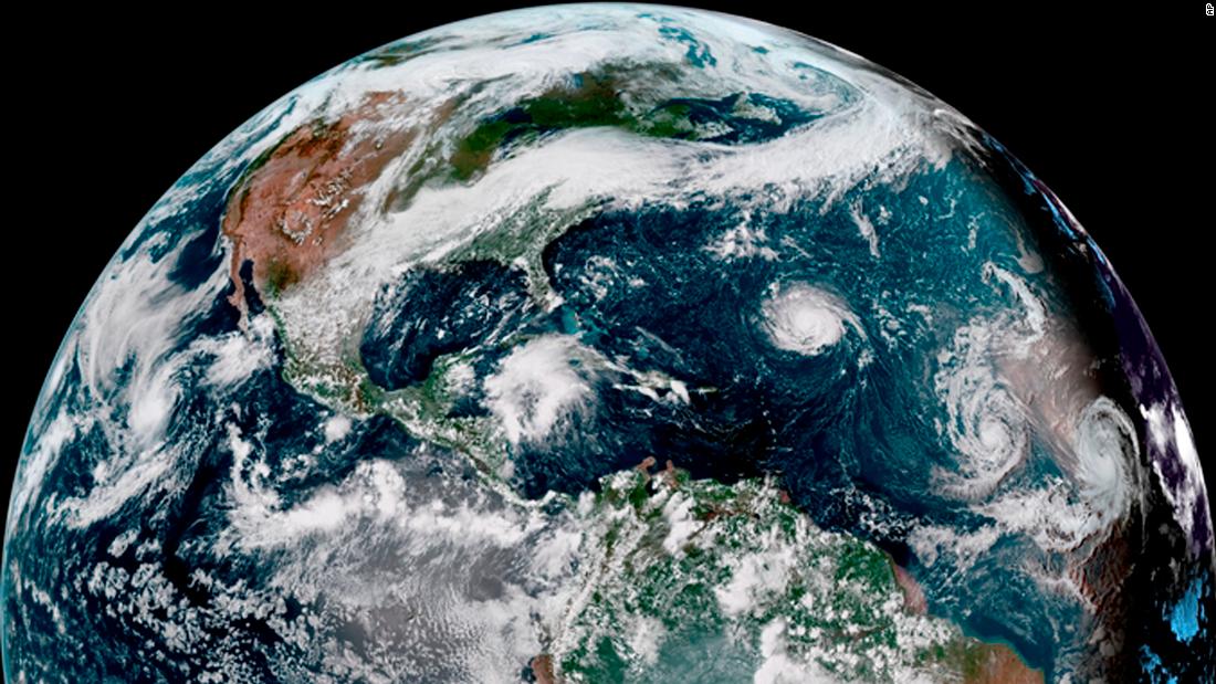
Further strengthening is expected, as Florence moves toward North and South Carolina, where it could unleash its fury as the most powerful storm to hit the region in three decades.
A mandatory evacuation order was issued for North Carolina’s Hatteras Island starting at noon Monday, Dare County Emergency Management. said. The order extends to all residents and visitors in other areas of Dare County beginning at 7 a.m. on Tuesday.
The National Hurricane Center forecasts Florence to hit the shore late Thursday night or early Friday morning.
Swells up to 15 feet could batter the coast, Myers said, and the storm system is likely to stall when it crosses land, dumping up to 20 inches of rain on some inland locations.
The center of the hurricane was forecast to move between Bermuda and the Bahamas on Tuesday and Wednesday and approach the US coast on Thursday as a Category 3 storm or higher, according to the hurricane center.
Large swells generated by Florence are already affecting Bermuda and portions of the East Coast and will continue this week. “These swells are likely to cause life-threatening surf and rip currents,” the hurricane center said.
The governors of Virginia, North Carolina and South Carolina have declared states of emergency.
“We are preparing for the worst, and of course hoping for the best,” South Carolina Gov. Henry McMaster said, adding that his declaration would allow state agencies to deploy assets quickly to the coast. The state has begun enforcing a law against price gouging.
McMaster and North Carolina Gov. Roy Cooper have asked President Donald Trump for a federal disaster declaration. That would make state and local agencies eligible for Federal Emergency Management Agency reimbursement of some costs.
Cooper told residents on Monday to get ready to be without power for an extended period.
“North Carolina is taking Hurricane Florence seriously, and you should, too,” Cooper said.
He said he expects other coastal communities to follow Dare County and order evacuations either Monday or Tuesday.
Cooper also urged people to learn what evacuation routes to take, and put fuel in their vehicles in case they’re ordered to leave.
“Action today can avoid losses due to Florence,” he said.
Some are evacuating
Crystal Kirwan and her family were preparing to leave their home in Moyock, North Carolina on Monday.
“This one is hard,” she told CNN. “We live paycheck to paycheck, being a military family, and it’s four days until payday.”
She, her husband and children will make the four-and-a-half-hour drive to family in Dover, Delaware, as soon as he is cleared from duty. “Probably not too much better, but most likely safer than here,” she said.
Meanwhile, crowds formed at supermarkets starting Sunday as people tried to stock up on supplies.
Erin Byrd checked in online from Publix in Apex, North Carolina.
“Water supplies being depleted. … Bread and milk supplies still robust,” she posted on Instagram.
“We don’t panic, which is why we are amused that water was so depleted a week out. We still have water supply from last year here,” she told CNN.
Alicia Buchanan posted on Instagram from Walmart in Rock Hill, South Carolina. She just moved to the area two weeks ago from Northern Virginia and still doesn’t have her furniture.
“So, I’m prepping with some bottled water, a couple puzzle books, and making sure all my electronics and back-up batteries are charged,” she told CNN. “I plan to do most of my cooking on the grill.”
Peak season
Hurricanes Helene and Isaac are not expected to hit the US mainland.
Monday is the climatological peak date of hurricane season, the height of the eight-week period when the most powerful storms usually form, CNN meteorologist Pedram Javaheri said.
The Atlantic hurricane season officially began June 1, but cooler water and higher wind shear — winds moving at different speeds and directions — early in the season are less than ideal for tropical systems to gain and maintain strength.
Storms increase in frequency and intensity by mid-August and into September as temperatures in the Atlantic climb to their highest levels, Javaheri said.
“Take mid-August to mid-October, that period accounts for 87% of category 1 and 2 hurricane days and a staggering 96% of ‘major’ hurricane days — (Categories 3, 4 and 5),” he said. “By late October, wind shear once again increases and the cooler autumn air filters farther south, allowing waters to begin their inevitable cooling process.”
CNN meteorologist Gene Norman compared the conditions to boiling water on a stove, with the water taking a while to react to an increase and then decrease in the temperature of the element beneath it.
“Even though the season starts in June, the Earth is just beginning to warm up from the summer sun. By mid/late August, temperatures near their peak, like that pot on the stove starting to boil,” he said.
“However, just as it takes a while to heat the ocean, it also takes a while for the latent heat stored there to dissipate, like that pot on the stove. This is why there can be strong storms lingering into October.”
[ad_2]
Source link


