[ad_1]
Several heat index readings came close to setting records across the eastern half of the U.S. on Friday, with the hottest temperatures still yet to come on the East Coast.
Interested in Weather?
Add Weather as an interest to stay up to date on the latest Weather news, video, and analysis from ABC News.
Des Moines, Iowa, saw a heat index reading — the “feels like” temperature due to the high humidity — of 119 degrees, just 3 degrees away from a record. The heat index was 115 degrees in Minneapolis with a dew point of 80, the highest recorded in eight years. The temperature was 93 in Chicago, with a heat index of 107, while it reached a temperature of 95 degrees in Washington, D.C.
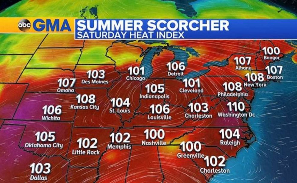
Many cities across the across the Midwest and Northeast started Saturday with heat indices in the 90s, and the day will be another scorcher with heat indices up to 115 degrees by afternoon. Excessive heat warnings have been issued from Kansas to Ohio and North Carolina to New Hampshire.
In Arkansas, Mitch Petrus, a former New York Giants offensive lineman, died Thursday of a heat stroke after working outside near Carlisle, according to the Associated Press. The heat index that day was higher than 100 degrees, according to the National Weather Service.
 ABC News
Some of the temperatures on Saturday will be the hottest in several years.
New York City and Philadelphia could see their hottest temperatures since 2012, while Washington, D.C., could hit 100 for the first time since 2016.
 ABC News
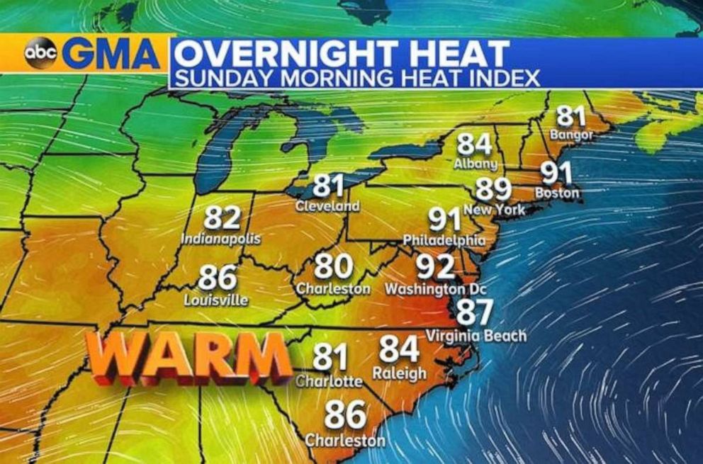
Overnight lows again will struggle to dip below 80, and it will already feel like 90 degrees when people wake up Sunday morning in Washington, D.C., Philadelphia and Boston.
 ABC News
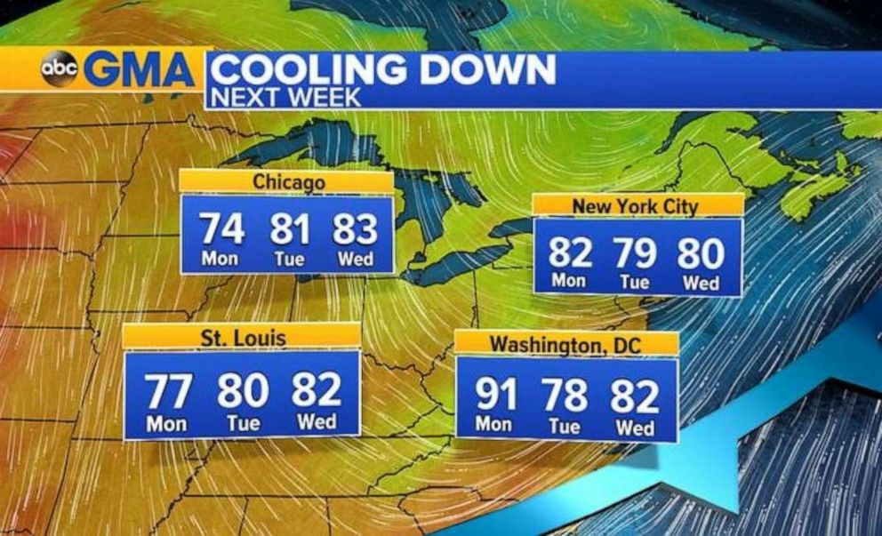
Sunday will be the final day of oppressive heat in the East before cooler temperatures arrive.
Temperatures will be much cooler than this weekend for the start of the work week, and will even be below average for late July with highs in the 70s across much of the Midwest and East Coast.
Severe storms
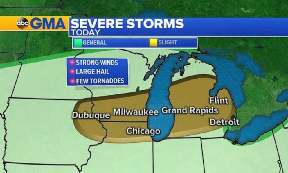
The dip in the jet stream and associated cold front bringing the cooler temperatures to the Midwest and Northeast will also bring severe weather.
 ABC News
There were more than 140 reports of severe weather Friday and overnight into Saturday from South Dakota to New York. Baseball-size hail damaged wind shields in Minnesota, while 84 mph wind gusts knocked out power in Wisconsin.
Heavy downpours, thunderstorms and 70 mph winds left thousands of people without power across Michigan. As of Saturday morning, 76,000 customers of Detroit-based DTE Energy were without power. At one point, 108,000 residents had been affected by an outage. Most people affected were located in the western suburbs of Detroit.
There is another chance for severe weather Saturday from Iowa to Michigan and another pocket in Colorado. The main threats will be for damaging winds, large hail and an isolated tornado.
[ad_2]
Source link

