
[ad_1]
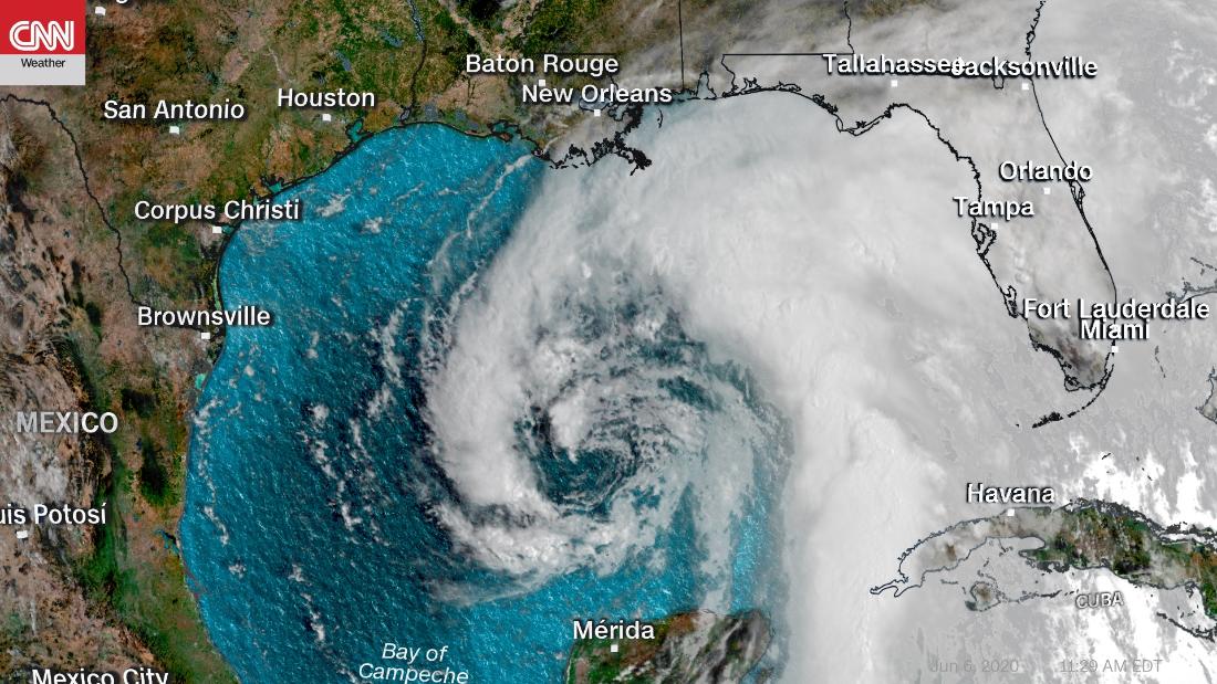
Tropical Storm Cristobal currently has sustained winds of 50 mph as it continues to approach the Gulf Coast. Cristobal is expected to maintain tropical storm strength through landfall later on Sunday.
“The earliest calendar year landfalling named storm in Louisiana on record (since 1851) is Tropical Storm Arlene on May 30, 1959,” Phil Klotzbach, a meteorologist at CSU, said on Twitter. “The 2nd earliest landfalling named storms in LA are unnamed tropical storms in 1912 & 1956 on June 13.”
Which means, according to Klotzbach, Cristobal will be the the second earliest named storm to make landfall in Louisiana since records have been kept.
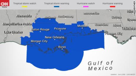
As for Cristobal’s landfall location, almost all models are in alignment and expect that point to fall somewhere between Marsh Island to Slidell, Louisiana. But this does not mean that locations outside this area need not pay attention. Tropical storm warnings are posted for much of the Louisiana coastline, Mississippi, Alabama and portions of the Florida panhandle.
“Do NOT focus on the center as impacts will occur outside of the cone, especially east of the center,” the National Weather Service in Mobile said on their website. “Heavy rainfall of 4-6″ with higher amounts up to 10″ possible for coastal Alabama and southeast Mississippi.”
Flooding will be the biggest concern
Regardless of where the storm makes landfall, impacts will be felt hundreds of miles away. Neighboring states to the east such as Florida, Alabama, Mississippi, Georgia, even the Carolinas will each pick up several inches of rain in a short period of time which could trigger flash flooding.
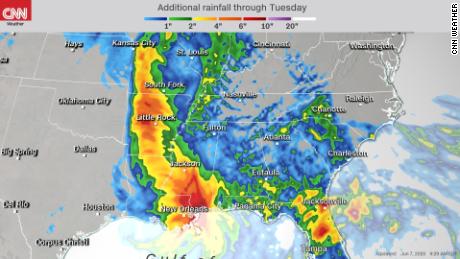
Widespread rainfall along the coast will likely be in the 5-10 inch range, with some areas picking up at least a foot total. These numbers alone would be impressive and cause flooding, but the problem for some of these states is that they have been dealing with excessive rains for the past month, so the ground is already saturated. This will exacerbate the flooding concern for states like Louisiana, Arkansas, and Florida, which have already received at least 8-10 inches in just the last 30 days.
Once the storm makes landfall it will continue to progress northward into states including Iowa and Wisconsin that rarely see tropical systems in their backyard. While the storm will significantly weaken once it makes it that far north, it will still be able to produce several inches of rain for cities like Madison and Oshkosh, Wisconsin, as well as Cedar Rapids and Dubuque, Iowa.
In addition to most Guif Coast states, Arkansas and Missouri are also under flood watches in preparation for heavy rainfall to those states in the next 72 hours.
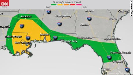
Tornadoes likely along the Gulf Coast
Another concern is the potential for severe weather. The Storm Prediction Center has issued a “slight risk” for the coastal regions of Louisiana and Mississippi. A “marginal risk” has also been issued and encompasses the slight risk in addition to portions of coastal Alabama and the Florida panhandle.
“Tropical storms like Cristobal can still be prolific tornado producers, especially when making landfall on the Gulf Coast,” said CNN meteorologist Brandon Miller. “Landfalling tropical systems from the Gulf of Mexico produce more tornadoes than their counterparts making landfall along the Atlantic coast, largely because the right-front quadrant (where most tornadoes are found) is located completely onshore.”
The first Tornado Watch of the day was issued around 9 a.m. CT Sunday, which includes the coastal regions of Mississippi and Alabama and is valid until 5 p.m.
In Florida Saturday there were seven tornado reports, including one that hit near downtown Orlando. At least three homes were significantly impacted by storm activity, according to a city spokesperson.
For a time, SeaWorld and Universal Studios were under a tornado warning and a funnel cloud was sighted.
[ad_2]
Source link